6th March till 13th March
We found our way to Derwent Bridge, which is on the Southern end of the Cradle Mountain-Lake St Clair National Park. The Lyell Highway, on which we travelled, marks the end of the Rivers Run Touring Route at Derwent Bridge and the start of the Western Wilderness Touring Route. Rather than paying for our camping at Cynthia Bay Campground on Lake St Clair, we decided to camp free on Lake King William. The view from the campsite looks over rather stark but strangely photogenic dead tree stumps. We were the only campers here, so it was peaceful, but felt also isolated. Although the bumble bees in this area kept us company, we were wishing they would disappear for a while. Those bumbles bees are the size of sparrows I swear. We were extremely lucky with the weather, with clear blues skies and no wind, which adds to the ambience of any campsite. We again attempted to catch fish, and spent a few hours doing so, but to no avail.
The Wilderness Hotel at Derwent Bridge is a very very nice spot to enjoy the odd beverage. From the outside it doesn’t inspire, but when you enter the doors it is very beautiful. There is a huge fireplace with chimney separating the bar from the lounge area and dining room. In the lounge area we sat down with our drinks and realised it was the first time we had actually sat on a couch for over 7 weeks. It was divine, very comfortable and we wanted to stay but had to go back to the camper, which by the way is very comfortable, and has the best bed ever.
We visited Lake St Clair, which isn’t really as pretty as I expected, but it is the deepest freshwater lake in Australia. I wasn’t as inspired to take photos here as I have been for most part of our trip. We have been to Cradle Mountain on a previous trip, the northern end, so I guess this part of the national park we didn’t find as interesting. Although at the Tourist Centre we were fascinated by the history of the area and spent a long time viewing the displays there.
Then we visited the highlight of our stay in Derwent Bridge, the Wall in the Wilderness. I really don’t know where to begin to describe this beautiful work in progress by sculptor, Greg Duncan. Unfortunately cameras are not allowed into this site, an understandable rule, but if only I could have captured some of his work, it is truly inspiring. The Wall will eventually span 100 metres; it is currently 50 metres. The detail this man provides in his sculptures has to be seen to be believed. His inspiration comes from the history of the area, including the timber industry and the Hydro schemes. An example is the pair of overalls worn by the workers; it is sculpted from Huon pine and hangs on a hook, with a cap sitting on top. How he actually gets the whole thing to look as though it is draping is amazing. Another example is the arms of the workers and how he has carved the muscles and the veins to look incredibly real. The wall shows his progress, with sketches and carvings as well as some completed work, so the visitor can grasp the magnitude of the project. This is a must not miss experience.
We then packed up to head to Queenstown for one night before heading to Granville Harbour on the West coast. Poor old Queenstown is not a very pretty place, but the road into it is an experience. A long steep winding road, where one minute you are looking at cliff faces and the next you are peering over a sheer drop. I took a video of that experience, which was the highlight of our trip to Queenstown, except that I was able to catch up on the laundry, eat a pizza for the first time in 8 weeks and had an ensuite in the cabin we stayed in. But the bed was like a block of concrete to lie on. Some of Queenstown’s more redeeming features, which is what we have found everywhere in Tassie, is that it offers great customer service, from the Pizza man to the IGA checkout girl and the bottle shop assistant. They always serve with a smile and seem genuinely pleased to be helping you.
After our one night in Queenstown we headed to Granville Harbour on the West Coast. It is a very beautiful place and although we decided not to camp there, we did attempt a very challenging 4WD track. The track is very sandy with steep descents, steeper inclines and lots of waterholes to cross. It eventually goes along the most beautiful pristine beach on the West Coast and onto Pieman Head and the Conical Rocks. We were enjoying the challenge and were pleased with the way the cruiser and the camper were handling it and then we got bogged twice. We were able to get out this trouble but we came across some others coming back the other way, who suggested that with the camper trailer in tow, it probably wouldn’t be a good idea to continue. So regrettably we turned around and headed back. We then decided to continue to Corinna, which turned out to be the best decision we could have made; it is all in the timing.
Corinna is on the beautiful Pieman River and to get there from the south, you have to be ferried by the Fatman Barge. It only carries two vehicles at a time and runs on demand all year. Corinna was an old goldmining town with a population of over 2000 people in its heyday, but when the boom was over the population was reduced to only the boatman for 38 years. When we arrived it was a hive of activity, there were vehicles queued up on the Corinna side to get across, but strangely no-one on our side to go into Corinna. When we got across and went into the beautiful and very rustic Tarkine Hotel; we found that the Western Explorer Road which was to take us to our next destination, Arthur River, was closing at 7 am the next morning for eleven days, to replace the bridge which crosses the Savage River. It was our intention to camp at the Tarkine Hotel for a few days, as we would have had great access to the river and it truly is a magnificent area to explore. We had to decide whether to stay there for that long, travel the other route, which took us out of our way by about 170kms or leave straight away.
We decided to have a drink instead, as you do. We were sitting on the veranda of the hotel, watching all the activity, when I heard a voice exclaim “Christine Sheedy”! It was a colleague of mine from Deakin, Sue Findlay. Sue and her husband Stephen have also been travelling around Tasmania, but the opposite way to us. What a wonderful surprise. It doesn’t matter how many wonderful people you meet, it is always special when you run into someone from home. So we spent the next couple of hours chatting and catching up with each other’s travel adventures. As much as we wanted to stay, it was getting late; we needed to make a decision and were told about a little camping spot 2 km’s away to the other side of the bridge that was to be closed. There is only enough room for one vehicle to camp, so we drove to this spot, found it empty and set up for the night. We were the last ones to cross that bridge before its refurbishment. It was a beautiful little spot, except that the workers arrived at 5.30 am the next morning to commence their work on the bridge.
Next we headed out onto the Western Explorer Road towards Arthur River. What a road this is. No scenery to speak of, very stark and in Greg’s words about 5 km into the trip “what idiot decided to build a road here”. It is the windiest, steepest road we have ever been on and it is mostly pot holed gravel all the way. The climbs were so steep that we had to use 1st gear to get the cruiser and camper over them; the descents so steep that we had to brake all the way down. We were only able to average 35 km per hour for most of the way due to the sharp and loopy bends in the road and the climbs. But we made it and set up camp at a beautiful spot called Sundown Point at Nelson Bay about 12 kms south of Arthur River. Thanks to Sue who suggested this spot.
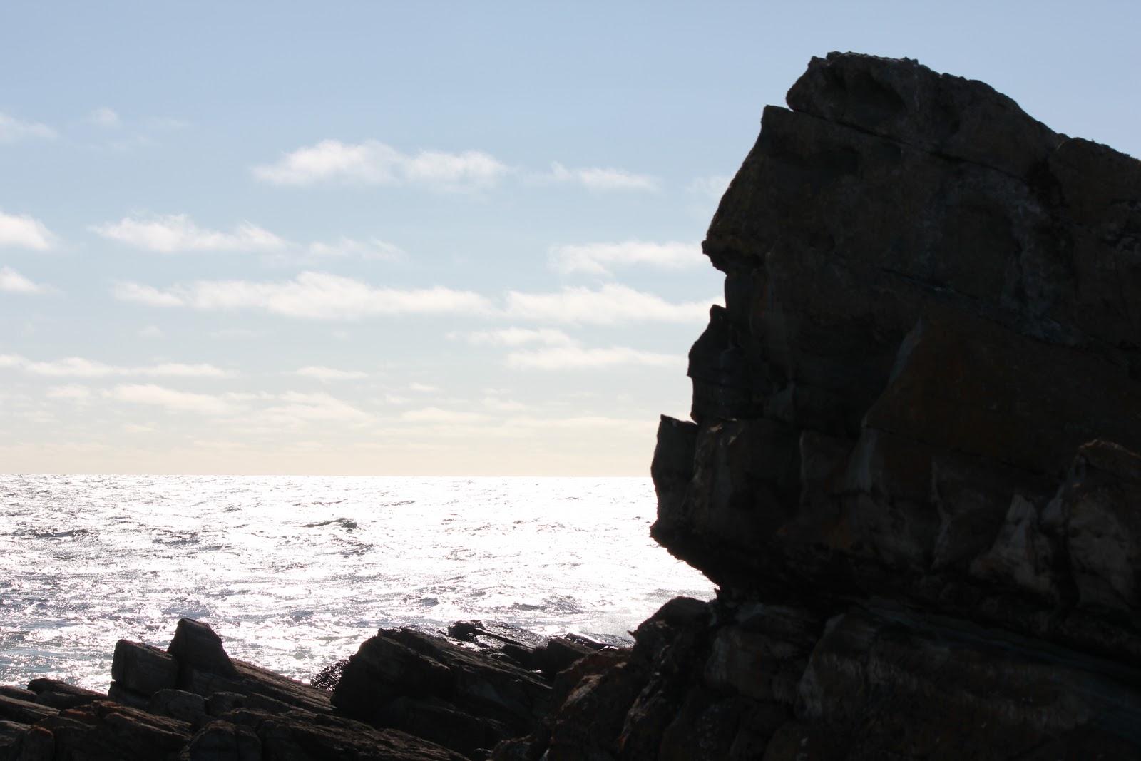
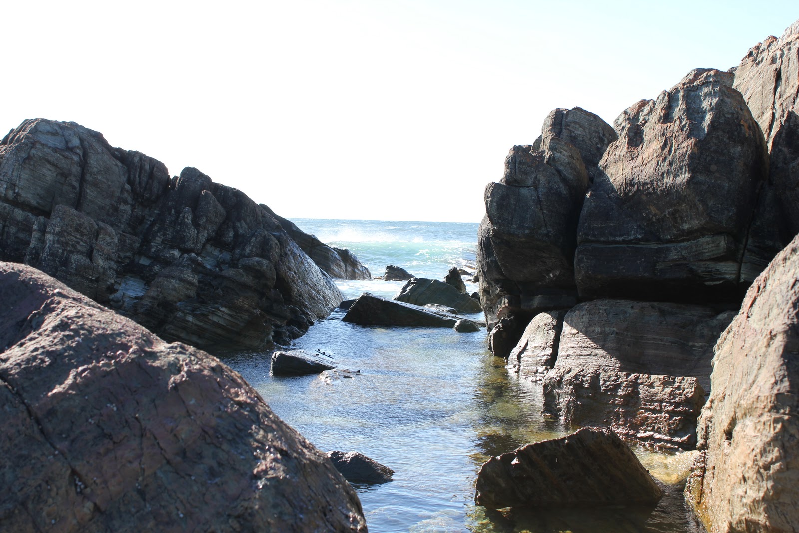
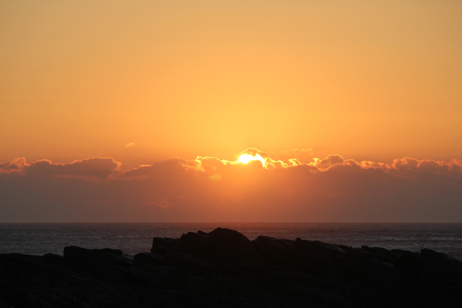
Sundown Point is on the Wild West coast of Tasmania in the Arthur- Pieman Conservation area and there really are no superlatives to describe how beautiful it is. Our campsite faces west and we are about 20 metres from a craggy rock- lined pool, through which we can view the wild Southern Ocean. I have never ever witnessed such wild water. It seems to come from all directions and the swell is absolutely huge. Waves crash a mile or so from shore. It is quite amazing to see the height of the swell which at times blocks our view of the horizon. Indeed the swells are so high on the horizon that it alters the way the horizon looks at times. We have witnessed three very stunning sunsets over the water, but on each occasion, the cloud hit the horizon before the sun did. The photos are still stunning. The weather has been perfect, although at times a little windy. But at least we didn’t get the wild westerlies blowing in on us. The walks over the rocks and along the wide beaches on this rugged coast have been the highlight of our stay here.
Arthur River is 12 kms north of Sundown Point and we drove there to see the “Edge of the World” viewing platform. This is Tasmania’s most westerly point of land (almost!) It is not possible for a boat to enter the mouth of the Arthur River over the shallow sandbar. The coastal waters are very wild and unpredictable. From there we drove to Marrawah which is renowned for its huge surf breaks. Lighthouse Beach is home to great surfing events and we were lucky to be there when the Ripcurl West Coast Classic was on at the weekend. We saw some up and coming young surfers take to the water and was able to get a few shots of them. The surf and the surfing were spectacular; the courage of these young surfers is amazing to see them in such wild surf.
We have spent 4 nights in this gorgeous area and have enjoyed every moment of it. Not sure where to next but we only have 8 days left of our Tassie Adventure. Will keep you posted. Cheers til next time.
 |
| View around our campsite at Lake King William |
 |
| View around our campsite at Lake King William |
 |
| View around our campsite at Lake King William |
 |
| Our campsite through the dead tree stumps |
 |
| Our campsite at Lake King William |
 |
| View around our campsite at Lake King William |
 |
| View around our campsite at Lake King William |
 |
| Lake St Clair |
 |
| Lake St Clair |
 |
| Hidden Valley on the way to Queenstown |
 |
| Granville Harbour |
 |
| Granville Harbour |
 |
| Granville Harbour |
 |
| Granville Harbour |
 |
| Fatman Barge at Corinna |
 |
| Sue and I at the Tarkine Hotel |
 |
| Greg and I on the Bridge at Savage River |
 |
| Our campsite at Savage River |
 |
| Our campsite at Savage River |
 |
| Part of the Western Explorer Road |
 |
| Our tent on the campsite at Sundown Point |
 |
| Our set up at Sundown Point |
 |
| View around the campsite at Sundown Point |
 |
| View around the campsite at Sundown Point |
 |
| View around the campsite at Sundown Point |
 |
| A small example of the swell at Sundown Point |
 |
| Waves crashing in the distance at Sundown Point |
 |
| Greg fishing on the rocks at Sundown Point |
 |
| Our beach at Sundown Point |
 |
| Sunset at Sundown Point |
 |
| Sunset at Sundown Point |
 |
| Sunset at Sundown Point |
 |
| Sunset at Sundown Point |
Sunset at Sundown
 |
| A fire to our east after sunset |
 |
| an hour after sunset- first crescent of the moon |
 |
| Surf at Marrawah |
 |
| The mouth of Arthur River from 'The Edge of the World' |
 |
| Surf at Marrawah |
 |
| Surfer at Marrawah |


No comments:
Post a Comment